Redrawing the lines in Northern Dutchess:  The making of North East

An 1867 map of the town of North East. The boundaries of North East changed drastically in 1823 after Pine Plains left to form its own town.

Courtesy North East Historical Society
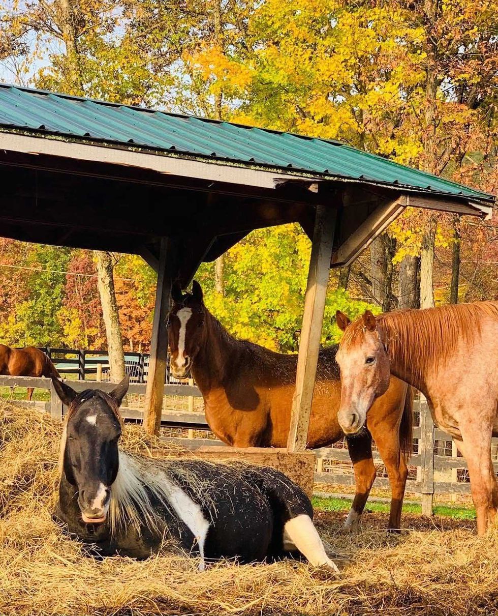
Redrawing the lines in Northern Dutchess: The making of North East

MILLERTON — In a November lecture at the NorthEast-Millerton Library Annex, William Tatum III, emeritus of the Dutchess County Historical Society, described how the map lines of the Town of North East were drawn, redrawn, and redrawn again.

“2023 is a big year for Dutchess because it is the 200th anniversary of a major change,” began Tatum. “It is the 200th anniversary of Pine Plains being established as an independent town.”

Tatum said he likes to give the “other side of the story. What about the old town? What about communities from which these new towns came?”

He gave a timeline:

— In 1683, Dutchess County was established as a “paper entity.” It was one of New York’s original 12 counties, 10 of which survive. Two were “bartered away” said Tatum, to get another territory in 1731.

— 1737: North East is established as a precinct.

— 1788: North East is incorporated as a town.

— 1818: Milan splits from North East.

— 1823: Pine Plains becomes an independent town.

Precincts — a Colonial term used instead of “towns”— were formed in New York when a group of partners “formed a patent,” and then would seek out Indigenous tribal leaders to “buy” land from them.

Tatum said they would buy “a vaguely defined amount” of land. He gave an example of how what would become Rumbout (Rombout) was purchased: from the top of Mount Beacon, the partners declared, “We are purchasing all that we can see.”

After the purchase, this patent would have to be approved. First, the paperwork was sent to Manhattan, where it was looked over and approved or rejected by authorities there.

If approved, it went on to London (a six-week to three-month trip depending on “the time of year and prevailing winds”), where it needed approval from the Board of Trade.

Then it would go to the crown, where it needed to approved by the king’s ministers, and then finally to the king or queen.

If approved, it then went through all these steps in reverse, until it got back to the Colonies, where the land claimed in the patent became a precinct.

In 1706, eight investors plus one silent partner, all men “well placed and influential” in society, formed Little Nine Partners Patent for the area of North East; their patent was officially approved by Queen Anne in 1708.

In 1731, “The Oblong” was added to the territory by the Treaty of Dover. This is when two counties were “bartered” to Connecticut for the Oblong, and North East gained its panhandle.

In 1744, after 40 years, the Little Nine Partners Patent (consisting of Dutchess County) was finally divided into seven precincts (South, Rumbout, Beekman, Poughkeepsie, Crum Elbow, Rhinebeck and North East). “Lots were assigned by lottery with two young boys under the age of 16 drawing the assignments” said Tatum. “I like to imagine it was out of a hat, but out of some kind of container.”

Once the patent was divided, it could be sold or rented to the colonists.

To form a new town, colonists had to advocate with petitions and letters to the State Assembly, so that the state would pass a law establishing a town.

Milan split from North East in 1818 to form a new town, and North East lost one-third of its territory. Due to a fire at the state capital in 1911, many of the records of how and why Milan split from North East were lost.

Then in 1823, Pine Plains decided to form an independent town. This was a problem since it left North East with “a whole new series of boundaries, because to keep that community viable, you had to take roughly the northern third of Amenia,” said Tatum.

Tatum added, “And some people are still not OK with that secession of territory from one town to the next.”

Tatum continued, “To divide town A and B was somewhat simpler” but what “North East of 1823 faced was as complicated as it could be.”

The center of North East’s government had to be moved from its seat in what had become Pine Plains. Accounts and paperwork had to be divided between North East and Pine Plains, and then this had to be done again with the new territory gained from Amenia. New officials had to be appointed and elected.

After 1823, “Little was left of the old North East” and it had a “brand new civic identity,” concluded Tatum.

Latest News

Upstate Art Weekend brightens Wassaic and beyond

Maxon Mills in Wassaic hosted a majority of the events of the local Upstate Art Weekend events in the community.

Photo by Mia Barnes

WASSAIC — Art enthusiasts from all over the country flocked to the Catskill Mountains and Hudson Valley to participate in Upstate Art Weekend, which ran from July 18 to July 21.

The event, which “celebrates the cultural vibrancy of Upstate New York”, included 145 different locations where visitors could enjoy and interact with art.

Keep ReadingShow less
Green thumbs drawn to Amenia Garden Tour

A serene scene during the Garden Tour in Amenia.

Photo by Leila Hawken

AMENIA — The much-anticipated annual Amenia Garden Tour drew a steady stream of visitors to admire five local gardens on Saturday, July 13, each one demonstrative of what a green thumb can do. An added advantage was the sense of community as neighbors and friends met along the way.

Each garden selected for the tour presented a different garden vibe. Phantom’s Rock, the garden of Wendy Goidel, offered a rocky terrain and a deep rock pool offering peaceful seclusion and anytime swims. Goidel graciously welcomed visitors and answered questions about the breathtaking setting.

Keep ReadingShow less
Tangled Lines: Casting into depths at dawn

Gary Dodson working a tricky pool on the Schoharie Creek, hoping to lure something other than a rock bass from the depths.

Photo by Patrick L. Sullivan

PRATTSVILLE, N.Y. — The Schoharie Creek, a fabled Catskill trout stream, has suffered mightily in recent decades.

Between pressure from human development around the busy and popular Hunter Mountain ski area, serious flooding, and the fact that the stream’s east-west configuration means it gets the maximum amount of sunlight, the cool water required for trout habitat is simply not as available as in the old days.

Keep ReadingShow less