Latest News
Oblong bookseller retires after 42 years on Main Street
Aly Morrissey
Feb 18, 2026
Longtime Oblong Books employee Lisa Wright in the Millerton store on Main Street. Wright will be retiring from her position on Monday, Feb. 23, after more than 40 years at the shop.
Photo by Aly Morrissey
MILLERTON — Longtime bookseller Lisa Wright has announced her retirement from Millerton’s Oblong Books, marking the end of a 42-year run that made her the longest-serving employee of the 50-year-old shop. She was among Oblong’s first booksellers and said her departure is bittersweet. “I decided I wanted to walk away while I still loved it,” she said.
Though she is stepping away from daily life behind the counter, Wright won’t be disappearing entirely from the store. Even after her final day on Monday, Feb. 23, she plans to continue writing her signature “shelf-talkers” — handwritten notes taped to the shelves to help browsers discover new books.
Wright’s relationship with Oblong began, fittingly, as a customer. She spent hours perusing the shelves and listening to music when the store was still located across the street from its current Main Street home. As business picked up and founders Holly Nelson and Dick Hermans decided to open on Sundays, Wright was offered a job.
“It started very haphazardly,” she recalled. “Needless to say, it was a lot smaller back then.”
Over the decades, Wright helped shepherd Oblong Books through many changes — including its physical move across the street. She remembers everyone pitching in to help, including a handful of their regular customers.
“It was fun, actually,” Wright said. “Hard work, but fun.”
In those early days, records were more popular than the books, and music was always playing in the store. Asked who chose the records, Wright didn’t skip a beat. “Dick,” she said with a smile.
Hermans, a longtime music aficionado, even hosted a radio show during those years — and he continues to share his love of music on the airwaves today.
Back then, most of the customers were regulars, Wright said, and tourism in Millerton hadn’t yet picked up. “We knew everybody,” she said, noting that times have changed. Now, some longtime customers steer clear of weekends to avoid the influx of visitors.
Through it all, Wright’s love for books stems from their ability to transport her to other worlds. She was first drawn to the fantasy genre, but her taste has evolved over the years to include nonfiction — especially narrative nonfiction because she loves a good story — and science. Ultimately, she said, the subject doesn’t matter as long as the author is excited about the topic.
“Those are always the best books,” she said. “If you can find one where the author is really excited about their subject, it’s wonderful, because you get caught up.”
While Wright said she couldn’t possibly name all of her favorite books, some recent recommendations include “Lessons in Chemistry” by Bonnie Garmus, “The Correspondent” by Virginia Evans and “Someone You Can Build a Nest In” by John Wiswell — all debut authors. The latter, she said, was particularly appealing because of its unique premise.
“It’s the strangest love story between a person and a monster,” she said.
She also always recommends “The Murderbot Diaries,” a series by Martha Wells.
“They are so funny and so touching, and the main character, who is a construct, is a little bit human, but not very much,” said Wright. “But he has overridden his governor module, so he doesn’t have to take orders from anyone anymore. And he’s having trouble understanding human beings.”
Wright estimates she reads about 100 books a year and believes the more you read, the faster you read. She also holds a firm — and often polarizing — rule.
“If you’re not in love with a book, stop reading it,” Wright said. “Reading should be fun and it should transport you. Don’t waste your time reading something you don’t like.”
She’s also a believer in the cognitive benefits of reading. “Your brain is imagining what you’re reading,” Wright said. “There’s nothing else that has that same effect.”
What she loves most, though, is sharing books with other people.
“It’s such a good feeling when they come back and say, ‘Oh, that book you recommended was so good.’”
For the foreseeable future, shoppers can still expect to find Wright’s legendary shelf-talkers at Oblong Books, guiding readers to their next story.
In a letter to the community, Oblong Books co-owner Suzanna Hermans said, “Lisa has been such an important part of my life, and of the lives of our booksellers over all these years - it’s hard to imagine our store without her.”
Keep ReadingShow less
Cascade Creek subject to full impact study
Leila Hawken
Feb 18, 2026
The proposed site of Hudson River Housing’s Cascade Creek workforce housing subdivision on Route 44.
Photo by Nathan Miller
AMENIA — The Planning Board voted Wednesday to require a more detailed environmental review of the proposed 28-unit Cascade Creek workforce housing subdivision — a move that could delay the project by six to 12 months.
Under the New York State Environmental Quality Review Act, the vote — known as a positive declaration — means the board determined the project may have significant environmental impacts that require further study before it can proceed.
Developer Hudson River Housing, a Poughkeepsie-based nonprofit, must now prepare a full environmental impact statement for the subdivision planned on 24.13 acres across Route 44/Route 22 from Freshtown Plaza.
“The positive declaration is a procedural vote to set the board on a path to create a full impact analysis, including completing a scoping process,” Planning Board attorney Victoria Polidoro said.
Board members identified four areas of potential impact, reflecting concerns raised by residents: a possible rise in local school enrollment, adequacy of water supply for firefighting, increased traffic, and visual impacts that may be inconsistent with community character.
The developers of the Cascade Creek subdivision have appeared before the Planning Board for more than a year, drawing a mixed reception from board members and the public.
Detailed site plans cannot be prepared until the environmental review process is completed.
Residents provided input most recently during an informal public comment session at a Planning Board meeting on Wednesday, Jan. 14, expressing concerns over impacts on groundwater supply and other issues. George Bistransin presented a petition opposing the development with 204 signatures.
Project Engineer Peter Sander of Rennia Engineering reported that all concerns from the January meeting had been considered and responded to in reports to the planning board. Changes had been incorporated into the plans based on comments voiced, he said.
Cascade Creek is classified as a conservation subdivision. Sander said 59% of the acreage would be set aside for open space.
Sander said that since November, he has submitted additional data on construction phasing and timelines, completed a second traffic study in addition to one conducted in September 2025, and met with fire officials to incorporate their suggestions, including increased spacing between homes and the use of fire-retardant materials.
“We feel we have provided sufficient information,” Sander said, asking that steps be taken to complete requirements for the conservation analysis phase, allowing the project to reach the design process when actual plans can be presented.
Sander projected that an estimated seven to 15 students might be added to the Webutuck School District as a result of the development, noting that he had difficulty in receiving a response to questions about Webutuck School District’s capacity for students.
Board members discussed how best to estimate potential enrollment increases and the difficulty of predicting how many school-age children might live in the homes.
“We are not school district predictors,” said Mary Linge, HRH vice-president for Real Estate Development, reasoning that other sources should be able to provide reliable data.
Adequacy of water supply to combat a home fire was a focus of board discussion, particularly a suggestion from local fire officials that a 180,000-gallon water tank would be needed for the purpose. Planning Board members debated how the matter could be resolved through compromise and the difficulty of reaching a decision without expertise in water supply standards.
“We’re just here for SEQRA impact now,” Sander said. “We’ve responded to fire department and citizen input. We’re going to work with you. We need your guidance.”
Planning Board member Nina Peek said the board should continue the process and move toward a public hearing once the impact statement is prepared.
Keep ReadingShow less

Want more of our stories on Google? Click here to make us a Preferred Source.
Pine Plains surveillance controversy prompts questions in other communities
Nathan Miller
Feb 18, 2026
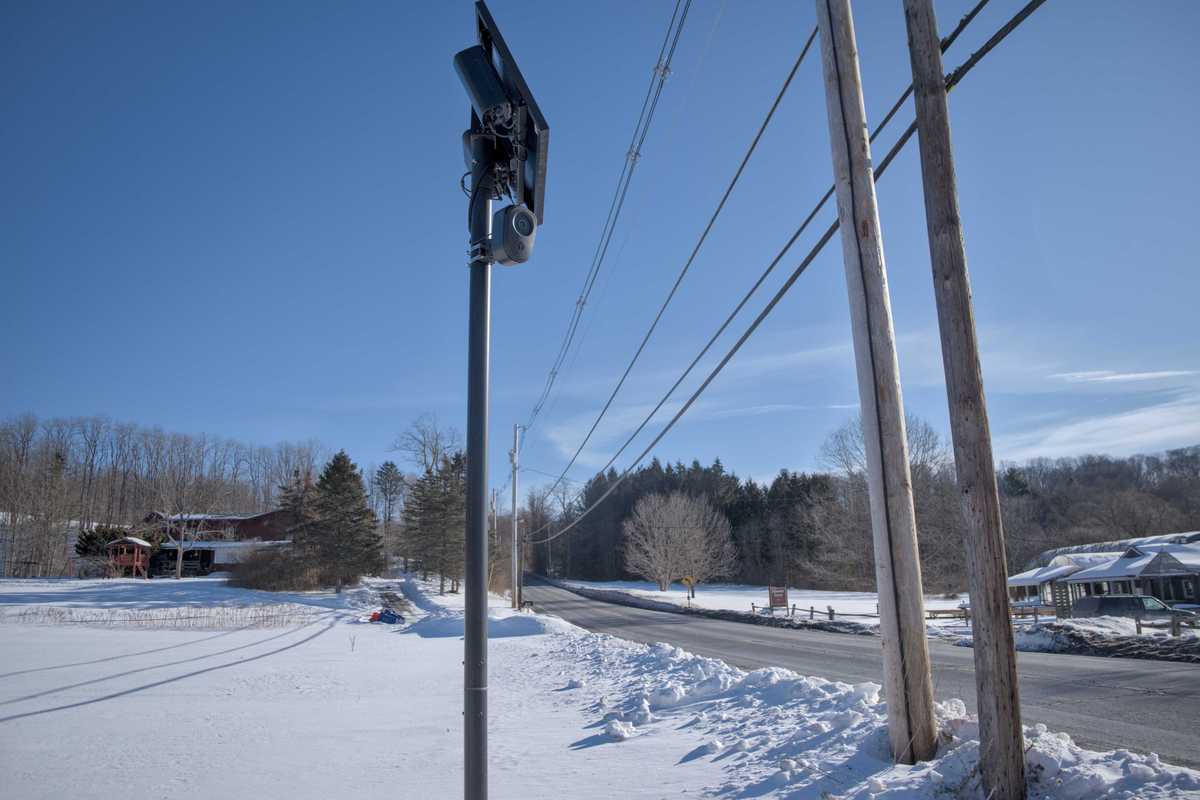
A license plate reader camera manufactured by Flock Safety captures images of drivers on Route 22 in the Town of North East.
Photo by Nathan Miller
The discovery of site markings suggesting surveillance cameras were being installed in Pine Plains prompted town officials to call an emergency meeting last week to clarify their position on the controversial technology.
The meeting, held Monday, Feb. 9, followed public outcry. Officials explained that the proposed cameras — license plate readers — were set to be installed on local roads.
In response to the criticism, Town Supervisor Brian Walsh said in a prepared statement that a member of the Pine Plains Police Department signed a contract in February 2025 with Atlanta-based surveillance company Flock Safety. He said the Town Board was not consulted and did not authorize the agreement.
Town officials said the project will not move forward and that the planned installation of the cameras has been halted.
The controversy also spilled over into neighboring Millerton, where residents questioned the Village Board of Trustees about potential surveillance efforts. Board members and Village Mayor Jenn Najdek said neither county officials nor representatives from Flock Safety have contacted the village about installing cameras.
License plate readers manufactured by Flock Safety started proliferating across Dutchess County after District Attorney Anthony Parisi and the Dutchess County Sheriff’s Office secured funding for a unified surveillance system known as the Analysis and Real Time Crime Intelligence Center at the end of 2024.
The network comprises 371 cameras across the county, according to transparency.flocksafety.com/dutchess-county-ny-so, which serves as the county’s “transparency portal” for the Flock network. That network includes a camera in the Town of North East on Route 22 across from Silamar Farms and several temporary cameras in a neighborhood in the village of Millbrook.
Town of North East officials said they had no knowledge of the camera located on Route 22 near Harney & Sons Fine Teas Headquarters.
Najdek said she also was unaware and noted that the village has no jurisdiction over that location.
Millbrook Village Clerk Sarah J. Witt said she was unaware of the temporary cameras in the village located on light poles along Reservoir Drive and Maple Avenue.
Town of Washington officials in Town Hall on Reservoir Drive said they had noticed the cameras, but didn’t know why they were there, saying most of the traffic in the area is churchgoers, children and residents.
Village Mayor Peter Doro said he became aware of the cameras after Millbrook residents began asking questions, at which point Parisi told Doro the cameras were related to a covert, targeted surveillance operation and asked him not to share the information publicly.
In an email, Parisi said four cameras were installed in Millbrook after threats were made against a judge who lives in the village. He described the operation as temporary and said the cameras are set to be removed.
However, Parisi said the village had been notified before installation. “Prior to installation, the Village of Millbrook was advised,” he wrote.
The camera in North East, Parisi said, is permanent and part of a decade-old perimeter surveillance strategy that places license plate readers on major roads entering and leaving the county.
He said the camera is located on private property and is part of a broader effort to link private and public systems into a “professionally staffed, centralized intelligence center.”
Keep ReadingShow less
Local filmmaker debuts indie horror film at Millerton’s Moviehouse
Aly Morrissey
Feb 18, 2026
Keith Boynton
Photo by Aly Morrissey
MILLERTON — Local writer and filmmaker Keith Boynton premiered his indie slasher film “The Haunted Forest” on Friday the 13th at the Millerton Moviehouse in front of a hometown crowd, marking the movie’s first public screening — the same day it debuted on Amazon Prime Video and other platforms.
With a body of work spanning decades in drama and comedy — including “The Winter House,” starring Lily Taylor — this is Boynton’s first foray into the horror genre.
“As a filmmaker, I’m always thinking about what I can accomplish with the resources I have, what excites me, and what’s marketable to audiences,” Boynton, 44, said. “I go through phases where I think I’ve found ‘my genre,’ and then I move on.” He added that “The Haunted Forest” is his first horror film — an intentional choice because there is a market for it and enough overlap with his own interests.
Written and directed by Boynton, the film was primarily shot at a haunted attraction in Maryland in 2023 over a period of 18 days. The film follows a teen who takes a job as a scare actor at a haunted theme park — until “fake” scares turn deadly and bodies begin to pile up.
Boynton credits his brother Devin McEwan with the idea for the film. The pair worked on the outline together, and McEwan’s feedback shaped the story, Boynton said.
“I wrote a first draft that was just not ready for prime time because I didn’t understand the genre well enough,” he said. McEwan recommended a longer climax and more on-screen deaths to better fit the genre.
Although “The Haunted Forest” leans into familiar horror tropes, Boynton said he does not see the genre as the driving force behind his work. “I’ve been thinking a lot about genre, and I think the purest approach is not to care about genre at all,” he said. “I want to make movies that feel like movies.” He said some of the best movies change genres halfway through, including one of his favorites, Fight Club. “It changes genre and tone, but always feels like the same movie,” he said.
Boynton said his local upbringing and theater experience at Hotchkiss shaped his creative path and influenced his decision to shoot many of his projects in the Hudson Valley.
Boynton said he has been writing since before he could actually write. Though he is too young to remember, his parents said he wrote a poem at age two and never stopped.
“I’ve always liked language,” Boynton said. “I’ve always liked playing around with words, so I think I’ve been some kind of writer for, let’s call it, 40-something years now.”
By age 13, Boynton found himself bored at his grandfather’s house in the era before smartphones and the internet, when he stumbled upon a paperback compendium of film critic Roger Ebert’s movie reviews.
Captivated by Ebert’s passion for cinema, Boynton said he was hooked.
“At first I thought I wanted to be a critic, too,” he said. “But eventually I realized critics are outside the party looking in, and I wanted to be inside the party making the movies.”
The fascination grew into a decades-long tradition of attending the Sundance Film Festival, beginning at age 17 and continuing through this year’s final festival in Park City, Utah. Sundance organizers have announced the festival will move to Boulder, Colorado, beginning in 2027.
But for Boynton, who consumed as many films as possible at Sundance for nearly three decades, one memory will stay with him for the rest of his life. It was the moment he stood next to his idol Roger Ebert at a Park City urinal.
“I did not have the courage to talk to him,” Boynton laughed. “It’s not the right venue to tell someone, ‘You changed my life.’”
“The Haunted Forest” is available for purchase or rental on Amazon and other streaming platforms.
Keep ReadingShow less
Former church building approved for multimedia academy
Nathan Miller
Feb 18, 2026
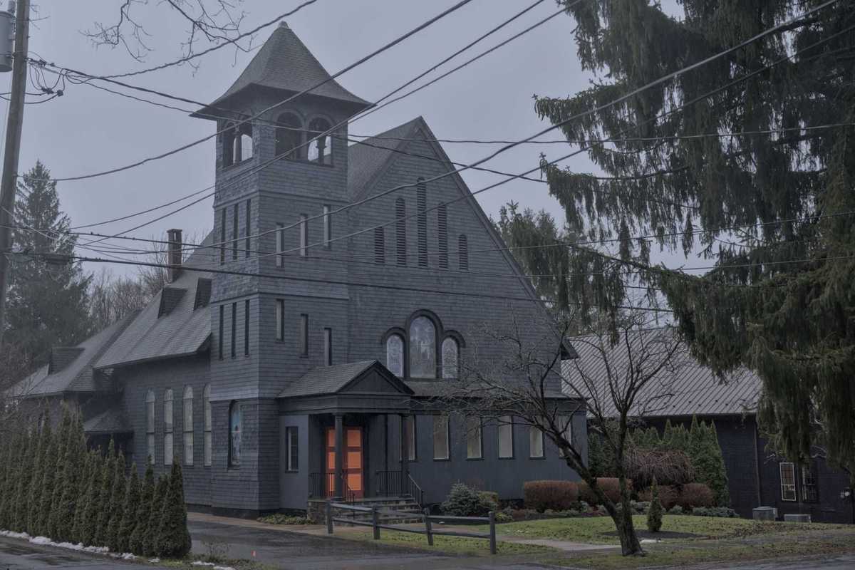
The former Presbyterian church on Main Street in Millerton will soon become the second location of Caffeine Academy, a multimedia education center originally founded in West Babylon, New York.
Photo by Nathan Miller
MILLERTON — The long-vacant Presbyterian church on Main Street is poised for a new life after the Millerton Planning Board granted approval to a new education business Wednesday, Feb. 11.
Caffeine Academy, founded by Alex That in West Babylon, New York, plans to transform the prominent building into a center for multimedia production training, offering instruction in digital music, video production and related arts.
That sought site plan approval to renovate the building and bring it into compliance with current accessibility standards.
The next phase for That is to obtain building permits from Ken McLoughlin in the village’s building department and begin construction. That said he expects to make changes over the course of 2026, with a targeted opening for the business in 2027.
That’s Caffeine Academy — which he runs with assistance from his sons — began in 2013 as a school for DJing and music production that grew to accommodate and cater to people with special needs and abilities. Now, Caffeine Academy offers classes for all abilities in video production and multimedia arts in addition to the digital music classes.
The application passed with little discussion. That previously appeared in front of the Planning Board in December, but delayed the application to wait for a local law to go into effect that waived increased parking requirements for changes of use in Millerton’s commercial district. The law allowed the application to avoid seeking a variance from the Zoning Board of Appeals.
Keep ReadingShow less

Want more of our stories on Google? Click here to make us a Preferred Source.
loading








Public debate on North East’s zoning rewrite to continue March 20
Nathan Miller
MILLERTON — Town Board members voted last week to continue the public hearing on the town’s proposed zoning overhaul, setting a new date of Friday, March 20, at 7 p.m.
The North East Town Board also scheduled a special workshop for Tuesday, March 3, at 5 p.m. to review public comments and concerns raised during February hearings, including calls for clearer explanations of the new code’s intent and requests to expand permitted uses in commercial districts. Board members set those dates at their regular meeting Thursday, Feb. 12, which included a public hearing on the zoning rewrite along with routine department reports.
North East’s 181-page draft zoning code would update much of the town’s existing regulations, with a particular focus on revising standards and approval processes in commercial districts to encourage development and expand housing opportunities. Public comment on the new zoning code during the hearing was brief. Just two people — North East residents Rob Cooper and Kathy Chow — offered comments at the third public hearing on the zoning overhaul since the Town Board opened debate on the draft on Jan. 8.
Cooper requested more permitted uses in the west Boulevard District, but he didn’t specify what additional uses should be included. The Boulevard Districts comprise parcels along Route 44 between the eastern border of the Village of Millerton and the Connecticut state line, and was a central focus of the current re-zoning effort.
Cooper said his property — the historic Mobil gas station on Route 44 across from CVS — is divided by the village border. “It divides the building in half,” Cooper said, explaining that Millerton land use regulations are more permissive than the Town of North East.
“Part of the property is in the village, and I’m allowed to do a tremendous amount of things over there,” Cooper said. “It wouldn’t look too uniform if I did everything on the left side of the property and we couldn’t do anything on the right side.”
Chow suggested the Town Board include purpose statements for each of the altered sections of the code. “Especially the Irondale district,” Chow said. “It’s a very different character than the boulevard and I’d like to see that explained.” She said some narratives explaining the changes and the purpose of the new code would be helpful for residents and developers seeking a deeper understanding of the process and how it benefits the community, echoing North East resident Ed Downey’s comments at a prior hearing.
In other business, Town Clerk Tilly Strauss read a complaint about gunfire noise at the Millerton Gun Club. Millerton resident David Decker submitted the complaint and asked to have it read into the public record, Strauss said.
The newly-formed Communications Committee provided an update following its first-ever meeting.
Councilwomen Rachele Grieco-Cole and Meg Winkler said the committee has set its sights on improving the town’s website, laying out short- and longer-term goals including basic readability and organization on the site’s homepage, revitalizing the town’s FaceBook page, and starting a regular digital newsletter to aid in proactive communication efforts.