
Latest News
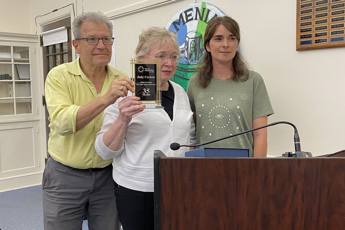
Long-term town employees were recognized at the Town Board meeting on Thursday, June 12. Honorees pictured with Town Supervisor Leo Blackman, were Judy Carlson, Office Manager at the Town Garage, center, for her 35 years of service to the town and Megan Chamberlin, current Highway Superintendent, for 20 years.
Leila Hawken
AMENIA — Acknowledging the many years of service accumulated by town employees, the Town Board paused to honor that service at its meeting on Thursday, June 12.
“Thank you for making a difference,” said Town Supervisor Leo Blackman in recognizing Judy Carlson, Office Manager at the town garage, for her 35 years of service.
“Megan’s job is not an easy one,” Blackman said, honoring Megan Chamberlin, current Highway Superintendent who has served the town for 20 years.
Also among those honored was Town Clerk Dawn Marie Klingner for 20 years of service as Court Clerk.
Maureen Moore, Court Clerk, was also honored in absentia for her 20 years of town service.
Keep ReadingShow less
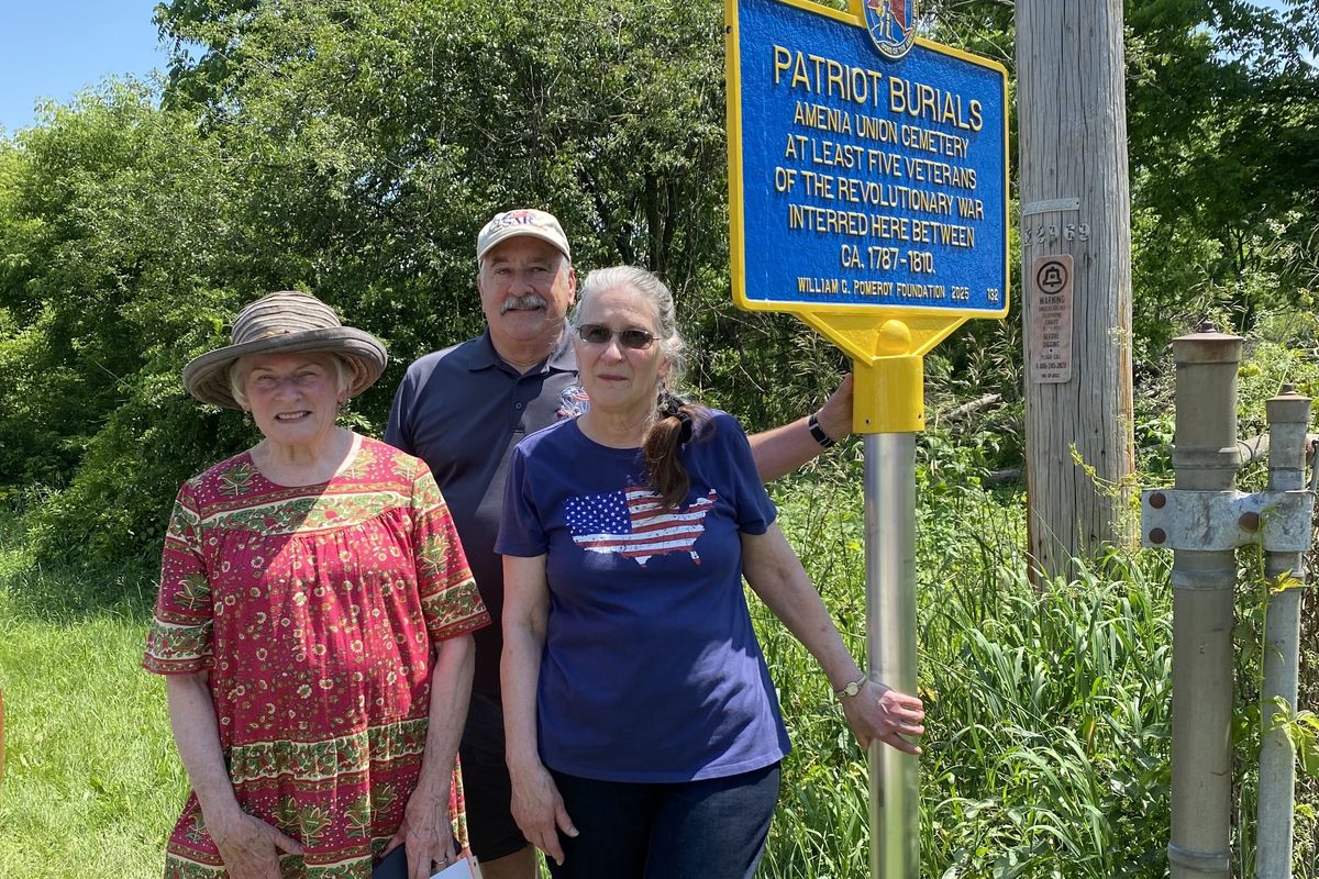
In anticipation of the celebration of the 250th anniversary of the start of the American Revolution in 2026, new historic markers are appearing at each of the local cemeteries where Revolutionary War veterans are buried. Unveiling the new marker at Amenia Union Cemetery on Saturday, June 21, were left to right, Town Historian Betsy Strauss, Jim Middlebrook representing the regional chapter of the Sons of the American Revolution, and Gail Seymour, President of the Union Cemetery Association.
Photo by Leila Hawken
AMENIA — One by one, new historic markers are appearing at local cemeteries where Revolutionary War dead are buried. On Saturday, June 21, community members gathered to see a new marker unveiled at Amenia Union Cemetery on Leedsville Road.
A tent provided welcome shade for the attendees and refreshments as about 30 residents gathered for the unveiling and to share stories of local history with one another.
As with the first historic market installation at the Old Amenia Burying Ground, held in April, Amenia Union Cemetery graves of Revolutionary War veterans had been marked with American flags in advance.
Jim Middlebrook, representing the Columbia Mid-Hudson chapter of the Sons of the American Revolution, attended along with other members of his chapter. Speaking before the unveiling, Middlebrook said that the historic marker project had begun in August 2024, and included a detailed process to certify the names on the graves.
Middlebrook described the work of the William C. Pomeroy Foundation of Syracuse whose mission is to promote “pride of place” by providing grants in support of installing historic markers and plaques nationwide to honor patriots for their service. Active now in seven or eight states, Middlebrook said, the foundation will soon add Connecticut and Massachusetts to the list.
The new Amenia Union marker honors “at least five veterans of the American Revolution interred between 1787 and 1810,” although Town Historian Betsy Strauss lists six veterans buried in the cemetery. The sixth, Gerhard Winegar, whose burial had been in 1781 could not fully satisfy the certification standards.
Strauss provided the following listing of six names:
Col. Colbe Chamberlain, 1739-1796
Capt. William Chamberlain, 1745-1810
Lieut. Samuel Snyder, 1712-1808
Gerhard Winegar, 1750-1781
Ensign Henry Winegar, 1723-1787
Capt. William Young, 1747-1806
Keep ReadingShow less
Bee Bee the clown, face painters and a community wide scavenger hunt are among the activities planned for the Millerton Street Fair in Downtown Millerton on Saturday, June 28.
Photo by Aly Morrissey
MILLERTON — The Millerton News, in partnership with the North East Community Center (NECC) and the Millerton Business Alliance, is hosting its first Street Fair on Saturday in a celebration of the town.
Rain or shine from 10 a.m. to 2 p.m, the fair will bring together local nonprofits and businesses, with live music, entertainment, kids’ activities, local eats, and family fun in Veterans Park, in front of the Millerton Inn, and beyond.
“The Millerton Street Fair will celebrate everything we love about this community — its spirit, its dedication to service and its creative energy,” said James Clark, publisher and CEO of The Millerton News.
Local nonprofits will showcase their work and impact, including Climate Smart Millerton, Eddie Collins Memorial Park, North East Historical Society, Townscape, Tri-Corner FEED, Village of Millerton, and the Webutuck Elementary School.Participating businesses include Bes, Little Red Bird Studio, NBT, The Elephant’s Tusk, and many more.Local retail and dining establishments will be open with special promotions. NECC’s Farmer’s Market will run during the event.
Among the planned festivities are live music from John Stey and the Resilience Brass Band, performances from Bee Bee the Clown, face painting by students from Webutuck High School, and a community-wide scavenger hunt for kids.Other kids’ activities include egg and spoon races, and a “touch-a-truck” open house at the firehouse.The Irondale Schoolhouse will be hosting a special exhibit, and the North East-Millerton Library will be offering signups for the Summer Reading Program, a science show from 11 a.m. to 12 p.m., lawn games, and a cookie cook-off.
For more information, go to millertonnews.com/street-fair.
Keep ReadingShow less
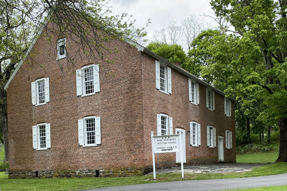
The Nine Partners Road Quaker Meetinghouse, built in 1780, will be the site of two summer lectures sponsored by the Millbrook Historical Society.
Photo by Leila Hawken
MILLBROOK — Long in the planning, the Millbrook Historical Society has announced that it is sponsoring two lectures in observance of the 250th anniversary of the American Revolution. Both lectures relating to Quaker history are to be held in the historic Quaker Meeting House on Nine Partners Road.
For the first talk, scheduled for Sunday, June 29, at 2 p.m., the historical society has invited Sarah Gronningsater, Professor of History at the University of Pennsylvania, to talk on “Quakers, Anti-slavery, and the American Revolution.” The topic will explore the role that New York’s Quakers, especially in the Hudson Valley, played in the rise of the anti-slavery movement that followed the American Revolution.
The second talk, scheduled for Sunday, July 27, at 2 p.m., invites Carl Lounsbury of the College of William and Mary and Colonial Williamsburg to speak on the architecture of the Nine Partners Meetinghouse. His talk is titled, “Nine Partners Meetinghouse Plan: A New Form in the Hudson Valley.” Expert in early American architecture, Lounsbury’s talk will compare Nine Partners with other later houses of worship in New York and New England.
Both lecture events will be held at the 1780 brick Nine Partners Quaker Meetinghouse in Millbrook. An earlier meetinghouse on the site had burned. The building has remained largely unchanged since the 18th century.
Given the age of the structure, handicapped access is limited and there are no rest room facilities.
Visitors should enter through the cemetery gate entrance.
The lectures are free and open to all, supported by a grant from the county and offered as part of Dutchess County’s participation in the nation’s 250th anniversary commemoration.
Keep ReadingShow less
loading